


Current weather situation across Alberta
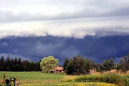
Between Wednesday, June 11 and the weekend, a developing low-pressure system is intensifying over central and southern Alberta, bringing much-needed rainfall, but also posing a heightened risk of very large hail and strong outflow winds.
According to Rhythm Reet, meteorologist with The Weather Network, scattered thunderstorms will affect the region over the next several days, with the greatest severity expected on Thursday, June 12, and Friday, June 13.
Thursday, June 12: Strong storms ignite off the Rockies
An active weather boundary is forecast to form along the Rockies, triggering severe thunderstorms. Communities like Red Deer, Calgary, and further south will be at greatest risk. By late afternoon, storm activity is expected to push eastward, expanding across a wider portion of the province. Expect very large hail, torrential downpours, and intense outflow winds.
Friday, June 13: New low develops, storms persist
Another low-pressure system will track northward on Friday, bringing steady rain to Edmonton and areas farther north. However, thunderstorm activity will continue to impact southern and central Alberta, with a renewed risk of damaging hailstorms near Calgary, Red Deer, and eastern regions.
Saturday, June 14: Lingering instability, uncertain storm zones
As the system shifts east into Saskatchewan, frontal boundaries will remain active over northern and central Alberta, allowing for continued thunderstorm development. The exact location and intensity of storms on Friday and Saturday carry the highest degree of uncertainty.
Rainfall amounts and expected benefits
Forecast models show totals between 40 and 80 mm across large parts of the province by the end of the weekend. This widespread rainfall will bring several key benefits:
1. Wildfire-affected regions will see improved conditions for fire suppression and a reduction in the potential for new fire outbreaks.
2. Agricultural zones across the southern Prairies will receive critical soil moisture, supporting crop growth during a crucial phase of the season.
However, not all drought-stricken areas will see enough rainfall to resolve ongoing moisture deficits.
Giant hail risk: A serious concern
The most dangerous aspect of this weather pattern is the potential for very large hail. Hailstones could reach golf ball to baseball size, capable of causing severe damage to vehicles, windows, roofs, and crops. This risk peaks on Thursday and Friday, especially in densely populated areas like Calgary and Red Deer.
Looking ahead: Hotter pattern returning by late June
Extended forecasts point to a return of hot and dry weather by the end of June, following this period of active storms and beneficial precipitation.
Stay alert to storm risks
Residents across Alberta are urged to stay weather-aware and closely monitor local alerts, particularly on Thursday, Friday, and Saturday when severe storm development will be most likely.


