


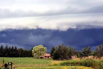
Severe weather alerts eased for southern Alberta on Saturday, as Environment Canada lifted multiple thunderstorm watches, including those for Airdrie, Crossfield, and other areas in southern Alberta.
Earlier warnings, issued for Calgary, Chestermere, and parts of Mountain View County, were downgraded during the day. The initial concern was due to storm cells developing along the eastern slopes of the Rockies, which were expected to move southeast, bringing with them the risk of damaging wind gusts, torrential rain, and hailstones as large as a loonie.
By 2:24 p.m. Mountain Time, the agency announced that “the risk of severe thunderstorms will diminish this evening.” Nevertheless, residents experienced intense lightning activity, large hail, and strong winds during the most active phase of the weather event.
One of the public advisories included the reminder: “When thunder roars, go indoors! Lightning kills and injures Canadians every year.”
Saturday’s local forecast for Airdrie had predicted a 60% chance of showers with a continued risk of thunderstorms in the afternoon. The temperature peaked at 20 °C (68 °F), under a UV index of 6, categorized as moderate.
For the evening, skies were forecast to gradually clear, following a chance of early showers and a lingering thunderstorm risk. Overnight lows were expected around 4 °C (39 °F).
Looking ahead to Sunday, sunny skies are forecast for Airdrie, with temperatures climbing to 23 °C (73 °F) and a UV index of 8, considered very high. The clear conditions are expected to continue into Sunday night, with temperatures dipping to 6 °C (43 °F).


