


Ottawa, Wednesday, June 4, 2025, 10:00 (local time) — A brief return of summer heat is gripping Southern Ontario, but change is on the horizon. After a cool and cloudy end to May, the start of June brings a notable rise in temperatures, hazy skies, and an increased risk of severe thunderstorms.
Heat builds across Southern Ontario under smoky skies
After several days of below-normal temperatures, Southern Ontario is now experiencing temperatures climbing toward seasonal norms, with highs forecasted to reach the upper 20s and even the low 30s°C (mid-80s to low 90s°F) in places like the Ottawa Valley, Golden Horseshoe, and Deep Southwestern Ontario. Despite the warming, a layer of upper-level wildfire smoke, drifting in from Western Canada, is dimming sunlight and holding back maximum temperatures slightly.
Though the haze and faint smell of smoke remain noticeable, much of this smoke is expected to lift by early Wednesday, improving both air quality and visibility. Still, lingering thin smoke layers could persist over regions such as Toronto, Hamilton, and the Niagara Peninsula, continuing to modestly suppress solar heating.
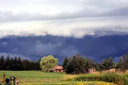
Cold front brings sudden cooling and severe weather risk
Beginning around mid-afternoon, a cold front sweeping in from the northwest is forecasted to deliver a swift temperature drop, sometimes as much as 10 to 15°C (18 to 27°F) within just a few hours. Initial impacts will be felt from the Bruce Peninsula to Parry Sound and North Bay between 2 PM and 4 PM, before sliding southeastward through the rest of the region.
This frontal passage also sets the stage for potentially severe thunderstorms, particularly from 3 PM to 6 PM, extending from Deep Southwestern Ontario through Kitchener-Waterloo, into the Lake Simcoe region, and up toward Algonquin Park.
Key threats include:
- Damaging wind gusts reaching up to 90 km/h
- Quarter-sized hail
- Localized flash flooding from slow-moving storm cells
- A low but non-zero risk of an isolated tornado, especially where converging lake breezes could briefly intensify rotation
After sunset, the risk of severe weather diminishes, though scattered, non-severe thunderstorms may persist into the overnight hours, particularly in the Golden Horseshoe and Eastern Ontario.
Local effects from lake breezes
While inland areas may flirt with 30°C (86°F) or higher, shoreline communities along Lake Ontario, Lake Erie, Lake Huron, and Georgian Bay will feel the tempering effects of lake breezes. These regions are expected to see highs in the more moderate range of 20 to 25°C (68 to 77°F).
This pattern creates notable thermal contrasts between inland and lakeside zones, which can contribute to storm development, particularly in regions where cool marine air meets hot, unstable interior air.
Pet safety during extreme heat
With temperatures rising and humidity increasing, it’s crucial to ensure domestic animals are not at risk of heat-related stress. Here are critical reminders for pet protection during hot weather:
A parked car can become a deadly oven in minutes. Even on a 24°C (75°F) day, the interior temperature of a car can spike to 38°C (100°F) within 10 minutes, and 49°C (120°F) in just half an hour.
If you spot an unattended pet inside a vehicle in Ontario:
- Try to locate the owner by checking nearby businesses.
- Contact authorities immediately, including the OSPCA at 1-833-9-ANIMAL (264625) or 911 if the pet appears in distress.
- Stay with the animal until help arrives.
Ensure pets have plenty of shade, access to fresh water, and are walked early in the morning or late in the evening to prevent paw burns and overheating.
More wildfire smoke possible later this week
While much of the upper-level smoke is set to dissipate by Thursday, new forecast data hints at another wave of wildfire smoke arriving by the weekend. These smoke intrusions, though mostly confined to the upper atmosphere, could again affect temperatures, visibility, and air quality in parts of Ontario.
Stay alert through Wednesday afternoon and evening for shifting weather conditions and possible thunderstorm watches or warnings, especially if travelling through central or eastern parts of the province.


